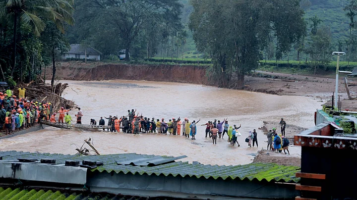
At the time of writing, the death toll from the landslide in northern Kerala stands at 276. Mundakkai, a hilly village in Wayanad, remains cut off, with hundreds presumed stranded. The Indian army is constructing a Bailey bridge to connect Chooramalai village and Mundakkai village. While locals claim that over 200 people are missing, the state government reports a lower number, 98. Approximately 1,000 families and 5,000 individuals have been affected. Around 3,000 people are being sheltered in more than 40 relief camps across 45 relief centres.
On Tuesday, between 12.45 am and 4 am, landslides occurred inside the forest, approximately six kilometres from Chooramalai which experienced 578 mm of rainfall in the 48 hours preceding the disaster, significantly more than predicted. The villages of Mundakkai, Chooramalai, Attamala, and Noolpuzha were affected by the landslides, with the most significant impact observed in Mundakkai and Chooramalai. The Iravahinji River in the region is now flowing in two directions from its original course, and Vellarmalla GVHSS, a school, is fully buried under clay and soil.
How Many Landslides?
A document presented in Parliament in July 2022 shows that, between 2017 and 2022, Kerala witnessed 2,239 landslides. In India, during the same period, the total number of landslides was 3,782. In other words, a little over 59 percent of the total landslides in India during those five years occurred in Kerala.
According to a 2024 deep learning study on landslides conducted by Achu AL, a landslide researcher at Kerala University of Fisheries and Ocean Studies, 13 percent of the land in Kerala is extremely susceptible to landslides. Among these areas, the districts of Idukki, Palakkad, Malappuram, Pathanamthitta, and Wayanad are highly vulnerable to landslide occurrences.
Talking to The Quint, Achu stated that there has been a 3.46 percent increase in the area classified as extremely susceptible to flooding since the 2018 Kerala floods, attributing it to the rise in rainfall caused by climate change.
According to an ISRO (Indian Space Research Organisation) study in 2022, between 2014 and 2021, a little over 6,000 landslides were reported in Kerala. The study also reveals that out of the 14 districts in Kerala, 13 are exposed to landslides and that although the northeastern states have many landslides yearly, they are not particularly vulnerable in terms of socioeconomic factors due to their lower population density and wide, unoccupied mountain areas.
“The vulnerability of the inhabitants and households is more significant in the Western Ghats due to the very high population and household density, especially in Kerala, even when fewer landslides exist than in the Himalayan regions,” the study adds.
Wayanad is part of the Western Ghats region.
Why Are Landslides a Recurring Phenomenon?
Talking to The Quint, Dilip Kumar PG, Assistant Professor and Head of the Department of Geology at Government College in Kottayam, explained that the topography of the state and the excessive rain due to climate change are the main reasons behind these landslides.
“The topography of Kerala is vulnerable to such calamities. Worsening the condition, excessive rain saturates the soil, leading to its dislocation and eventually resulting in a landslide,” Dilip Kumar said.
According to the Kerala Climate Change Action Plan 2023-30 document, Kerala is experiencing abnormal heat and rainfall and temperatures are projected to increase in all 14 districts of the state compared to historical periods. It also indicates that the mean annual rainfall is projected to rise in all districts and that the northern districts, including Wayanad, are expected to receive more annual rainfall.
Furthermore, Kumar added that human activities have accelerated these events, and micro-level climate change mitigation plans are needed to address future incidents.
Meanwhile, Dr Sajin Kumar KS, Assistant Professor of Geology at Kerala University, said that excessive rain is the main trigger behind landslides, with loose soil and weathered rocks adding as contributing factors.
“When all three conditions—excessive rain, loose soil, and weathered rocks—occur together, landslides happen,” Sajin explained, adding that if the slope of the area exceeds 20 degrees, the chances of landslides are high. He further noted that in most parts of the Western Ghats, including Wayanad, the slope is above 20 degrees, making these areas more susceptible.
Interestingly, Achu pointed out that due to climate change-induced excessive rains, even a 20-degree slope isn't required for a landslide. “When there is excessive rain, landslides can occur even on slopes of 10 or 15 degrees,” he stated.
Meanwhile, discussing casualties, Sajin said that while India has maps of landslide-susceptible areas, it lacks maps that predict the flow routes of potential landslides.“If we develop such maps, we could take preventive actions in advance and reduce the impact of these calamities.”
For instance, Switzerland already has a system in place to predict the flow routes of potential landslides.
What is the Solution?
Manoj Kumar B, an Assistant Professor at Government College, Kottayam who wrote a thesis titled The Politics of Environmental Governance – A Case Study of Western Ghats Region of Idukki District, told The Quint that preparedness, prevention, and mitigation are key components of environmental governance. He emphasised the need for coordination among various departments, including geology, engineering, revenue, and agriculture, with political leadership playing a central role.
He further suggested that states should design and implement specialised environmental policies based on factors like elevation, soil type, and watershed characteristics. A detailed survey should classify areas into risk categories and be conducted at the grassroots level with expert input, free from external pressures.
Manoj Kumar also highlighted that the Precautionary Principle and Polluter Pays Principle, recognised by the Supreme Court of India in the Vellore Citizens Welfare Forum case, should guide environmental governance.
He noted that while Section 31 of the Disaster Management Act mandates disaster management plans for each district, the Act lacks a comprehensive policy framework for land use, construction, and materials and criticised the system for being reactive rather than proactive, stressing the need for public access to information on potential disasters and special laws to address issues in hilly areas.
(Rejimon Kuttappan is an independent journalist, labour migration specialist and author of Undocumented [Penguin 2021]. This is an opinion piece and the views expressed are the author’s own. The Quint neither endorses nor is responsible for them.)
(At The Quint, we question everything. Play an active role in shaping our journalism by becoming a member today.)