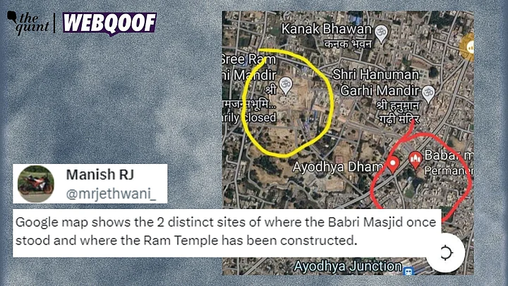
A screenshot of Google Maps is being shared on the internet with users claiming that the Ram Temple in Ayodhya is being built at a different site from where the Babri Masjid was demolished.
What have users said?: An X (formerly Twitter) user shared the image mentioning, "Google map shows the 2 distinct sites of where the Babri Masjid once stood and where the Ram Temple has been constructed."
Congress leader Digvijaya Singh (archive here) and Shiv Sena (UBT) leader Sanjay Raut (archive here), too, claimed that the temple is being away from the site of demolition.
Are these claims true?: No, it is clear that the marked place in the image showed Babar Masjid and not Babri Masjid.
Additionally, the place where the 'Babar Masjid' is shown marked is actually a temple named 'Shri Sita Ram Mandir'.
The Quint spoke to a Waqf sub-committee member who dismissed the viral claim.
Hints in the viral image: A closer look made it clear that the location marked in red was 'Babar Masjid' and not Babri Masjid. The yellow mark on the image showed 'Sree Ram Janmabhoomi Mandir'.
What did Google Maps show?: We searched for the name on Google Maps and found that the location pin was actually marked on a temple named 'Shri Sita Ram Mandir'.
The image used in the review section of Babar Masjid was an archival picture of Babri Masjid, which was taken before it was demolished.
Team WebQoof further contacted some locals in the area, who confirmed that there was no mosque in the same compound as the temple.
Comparing satellite imagery with archival image of Babri Masjid: We looked for old images of Babri Masjid on the internet and came across several uploaded in a report published in Times of India (TOI).
The image was taken hours before the mosque was demolished. A ditch of circular shape can be seen in the image, when observed closely.
There is also some space between the ditch and the mosque's fencing.
Next, we checked for the Ram temple on Google Earth that showed the construction of the temple. The location was identified as '26°47'44"N 82°11'39"E'.
Using historical imagery, we found a view from 2017 which was before the construction of the temple.
The ditch can clearly be seen here in the imagery as well. A closer look also showed a similar distance between the ditch and the outer boundary.
What did the Waqf committee say?: Team WebQoof reached out to Aazam Qadri, a Waqf sub-committee member, who said that the viral claim about the temple being constructed 3 kilometers away from the demolition site is "false". He added that the temple is being constructed in the same campus.
We have also reached out to the temple authorities and this report will be updated as and when a response is received.
Conclusion: It is clear that a screenshot of Google Maps is going viral with a false claim that Ram Temple is being built away from the demolition site of Babri Masjid.
(Not convinced of a post or information you came across online and want it verified? Send us the details on WhatsApp at 9540511818 , or e-mail it to us at webqoof@thequint.com and we'll fact-check it for you. You can also read all our fact-checked stories here.)
(At The Quint, we question everything. Play an active role in shaping our journalism by becoming a member today.)
