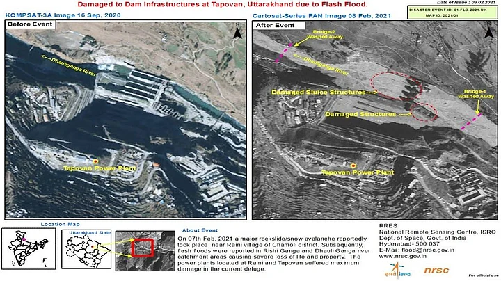
The Indian Space Research Organisation (ISRO) on Wednesday, 10 February, released the first images of the Uttarakhand glacier burst that has claimed 32 lives so far, while over 150 people remain missing.
According to the satellite images, the flash floods that are reported in Rishi Ganga and Dhauli Ganga river catchment areas are a result of a major snow avalanche near Chamoli district’s Raini village, and have resulted in major loss of life and property. The power plants located at Raini and Tapovan suffered maximum damage in the deluge, The Indian Express reported.
While one of the satellite image displays a huge deposition of debris in Dhauli Ganga, other images show the damage that has occurred in Tapovan and Raini’s dam infrastructure.
ISRO’s advanced earth imaging and mapping satellite CARTOSAT-3 photographed these visuals. It is a third-generation agile satellite with high-resolution imaging capabilities, The Indian Express reported.
These images come as multiple agencies are engaged in relief operations in Uttarakhand’s Chamoli and other areas. A DRDO team is working along with ISRO scientists and experts to ascertain the cause of the tragedy.
Rescue operations were intensified on Wednesday, 10 February, with the employment of drones and remote-sensing equipment to locate over 30 people trapped inside the 500-metre-long tunnel at NTPC’s Tapovan site.
All concerned agencies of the Centre and the state are monitoring the situation, Union Home Minister Amit Shah said in Rajya Sabha on Tuesday, 9 February, regarding the flash floods in Uttarakhand, while, scientists are investigating the cause of the glacier to break.
(With inputs from The Indian Express)
(At The Quint, we question everything. Play an active role in shaping our journalism by becoming a member today.)
